Nakhon Phanom Flood 2026: City Submerged August 10, South Thailand on High Alert
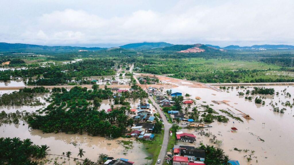
Nakhon Phanom flood 2026 — 107.9mm of rainfall from 5am on August 10 submerged roads and homes across the northeastern border city as drainage systems failed to cope and the Mekong River continued rising at 20–30cm per day.
Nakhon Phanom flood 2026 struck the northeastern border province overnight on August 10 — overnight downpours left submerged roads and inundated homes and businesses, prompting emergency drainage operations as heavy rainfall measuring 107.9 millimetres fell continuously from around 5am.
The Nakhon Phanom flood 2026 is the most significant urban inundation event in the province this monsoon season — and it has been accompanied by a simultaneous government directive ordering all 14 southern province governors to step up flood mitigation preparations, as a separate weather system threatens the Gulf Coast and Andaman Sea regions through the coming week.
What Happened in Nakhon Phanom: The August 10 Flood in Detail
Heavy falls brought by a monsoon trough stretching across upper northern Thailand and upper Laos lashed Nakhon Phanom from the early hours of Sunday. Rainfall was measured at 107.9 millimetres, with heavy to very heavy rain falling continuously from around 5am. Floodwater quickly accumulated across much of the municipality as drainage systems failed to cope with hours of intense rainfall.
Main and secondary roads were submerged, with water spilling into homes, shops and restaurants. Residents reported damage to household appliances and other belongings, including washing machines, refrigerators, gas stoves and mattresses.
The drainage system failure is the key infrastructural detail. Nakhon Phanom city sits on a plain adjacent to the Mekong River — the same Mekong that has been rising by 20–30 centimetres daily due to upstream rainfall in China and Laos. When the city’s drainage cannot discharge into a river that is already elevated, even moderate rainfall rapidly accumulates in urban areas. At 107.9mm in a single morning, the event overwhelmed the drainage capacity entirely.
Nakhon Phanom governor Adisak Noisuwan and municipal mayor Niwat Jiawiriyaboonma ordered an urgent multi-agency response to tackle the flooding. At least eight large water pumps were operating at key discharge points along the Mekong River to accelerate drainage from flooded urban areas. Disaster prevention officials, supported by soldiers, were distributing sandbags for use in barriers to affected households and maintaining round-the-clock monitoring.
Teams were dispatched to inspect high-risk areas, clear rubbish blocking drainage grates and provide assistance to residents. Provincial authorities warned residents in riverside districts of Ban Phaeng, Tha Uthen, Muang Nakhon Phanom and That Phanom, as well as communities near tributaries, to closely monitor conditions. People were urged to move valuables to higher ground and relocate livestock to safer areas if heavy rain persists.
The Mekong Rising: Agricultural and Tributary Impact
The Nakhon Phanom flood 2026 comes on top of an already stressed river system. Over the past week, persistent downpours have led to a rapid rise in the Mekong River, increasing by 20 to 30 centimetres daily. As of Thursday morning, the river level reached 8.20 metres — nearly one metre higher than three days earlier. Although still 3.8 metres below the critical overflow level of 12 metres, concerns were mounting.
The swelling Mekong River has begun to affect its major tributaries — Nam Kam, Nam Bang, Nam Songkhram and Nam Oun. More than 15,000 rai of paddy fields were submerged, with six districts declared disaster zones in the agricultural areas beyond the city.
The agricultural impact dimension of the Nakhon Phanom flood 2026 extends beyond the immediate emergency. The August timing is critical — rice in the northeastern Isan agricultural calendar is typically at the vegetative growth stage in August, making sustained inundation of paddy fields potentially damaging to crop yields at one of the year’s most sensitive points.
South Thailand on High Alert: The Simultaneous Warning
Alongside the Nakhon Phanom flood 2026 emergency, Thailand’s disaster management agencies have simultaneously activated preparedness alerts for the 14 southern provinces.
Response teams, machinery and temporary shelters are being prepared as six southern provinces monitor flood, landslide and rough-sea risks through August 7, 2026. Nation Thailand
The southern alert covers a different weather system from the northeastern monsoon trough. The provinces under warning include Ranong, Phangnga, Phuket, Krabi, Pattani, Yala and Narathiwat. The agency warned that accumulated rainfall could trigger flash floods and forest runoff. The TMD forecast widespread rain across the North and upper Northeast, with heavy rain in some areas, from August 2–10. Bangkok Post
The simultaneous northeast and south alerts mean that two of Thailand’s major tourism regions — the Andaman Coast (Phuket, Krabi, Phangnga) and the northeastern cultural circuit (Ubon Ratchathani, Nakhon Phanom, Sakon Nakhon) — are both under active weather warnings at the same time. This is not unusual for peak monsoon season in Thailand, but the convergence of a significant urban flood event in the northeast with the southern alert gives it unusual simultaneous headline prominence.
| Nakhon Phanom Flood 2026 — Key Data August 10 | Details |
|---|---|
| Rainfall recorded | 107.9 mm from approximately 5am |
| Areas flooded | Main and secondary roads, homes, shops, restaurants |
| Agricultural impact | 15,000+ rai paddy fields submerged |
| Disaster zones declared | 6 districts |
| Mekong River level | 8.20 metres — rising 20–30 cm/day |
| Critical overflow level | 12 metres — currently 3.8m below |
| Emergency response | 8 water pumps at Mekong discharge points |
| Affected riverside districts | Ban Phaeng, Tha Uthen, Muang NP, That Phanom |
| Governor directive | Residents move valuables, livestock to higher ground |
| Simultaneous southern alert | 14 provinces — 6 in active preparedness mode |
Four-Day Flood Warning: Which Provinces Are Covered
Thailand’s Department of Disaster Prevention and Mitigation issued a comprehensive four-day flood warning covering multiple regions simultaneously.
Northeast: Chaiyaphum, Nong Khai, Bueng Kan, Sakon Nakhon, Nakhon Phanom, Mukdahan, Amnat Charoen and Ubon Ratchathani. East: Prachin Buri, Sa Kaeo, Chanthaburi and Trat. Central: Kanchanaburi. West: Phetchaburi and Prachuap Khiri Khan. South: Phang Nga, Krabi and Phuket.
The northeastern list — covering eight provinces including Nakhon Phanom, Ubon Ratchathani, Sakon Nakhon, and Nong Khai — is the most extensive active flood risk zone in the country. The full Mekong River corridor from Nong Khai in the north to Ubon Ratchathani in the southeast is under active monitoring.
The southern list — Phang Nga, Krabi, and Phuket — covers Thailand’s most internationally visited beach destinations. Flash floods in Phang Nga municipality have already affected more than 300 households in previous weeks, described by residents as the most severe in at least 20 years.
People in affected areas should continue to follow official weather forecasts and announcements and avoid travelling through locations at risk of flooding, rapid run-off or mudslides. Residents living near foothills, waterways or in low-lying areas should prepare for possible emergencies.
What This Means for Indian Travelers in Northeast Thailand and the South
The Nakhon Phanom flood 2026 and the simultaneous southern alert have direct implications for Indian travelers on active itineraries in these regions.
Northeast Thailand (Nakhon Phanom, Ubon Ratchathani, Nong Khai, Sakon Nakhon): Indian travelers visiting the Northeast — for the Ubon Ratchathani Candle Festival sites, the Nakhon Phanom waterfront, the Nong Khai border area, or the Mekong River route — should avoid riverside walks, low-lying roads, and areas near Mekong tributaries during the active warning period. The 107.9mm rainfall that flooded Nakhon Phanom city centre on August 10 can recur on any day when the monsoon trough remains active over the region.
Southern Thailand (Phuket, Krabi, Phangnga): Indian families on beach holidays along the Andaman Coast should check daily weather updates before booking boat excursions, island-hopping trips, or open-water activities. The Andaman Sea wave forecasts cite 1–2 metres in the upper Andaman, rising above 2 metres during thunderstorms. Operators cancelling or postponing boat trips during active warnings should be given the benefit of the doubt — a cancelled excursion is recoverable, a capsized boat is not.
Transport disruption: Both the northeast floods and the southern weather system create road disruption risks. Mountain roads in Phang Nga and Krabi can be closed by flash flood runoff within minutes. Northeastern highways between flood-affected districts may experience temporary closures as water accumulates.
TMD hotline for weather updates: 1182. The Thai Meteorological Department issues updated warnings twice daily — check every morning before making outdoor plans during the active monsoon period.
Before any Thailand trip, confirm current entry requirements at thaievisa.go.th. India now has 30-day visa-free entry approved July 14 — awaiting Royal Gazette publication.
Complete the mandatory TDAC digital arrival card within 72 hours before departure. Remember UPI does not work in Thailand — carry Thai Baht or a zero-forex international card. For travel insurance covering flood-related trip disruptions, cancelled excursions, and transport delays in Thailand, SafetyWing Nomad Insurance provides comprehensive coverage at affordable daily rates for Indian travelers.
FAQs — Nakhon Phanom Flood 2026
Q: What caused the Nakhon Phanom flood on August 10?
Heavy falls brought by a monsoon trough stretching across upper northern Thailand and upper Laos lashed Nakhon Phanom from the early hours of Sunday. Rainfall was measured at 107.9 millimetres, with heavy to very heavy rain falling continuously from around 5am.
Floodwater quickly accumulated across much of the municipality as drainage systems failed to cope with hours of intense rainfall. The flooding was compounded by the already-elevated Mekong River, which has been rising 20–30 centimetres daily and was at 8.20 metres — limiting the drainage systems’ ability to discharge into the river.
Q: Which southern provinces are on flood alert simultaneously with the northeast?
The southern provinces under the simultaneous flood and rough-sea warning include Phang Nga, Krabi and Phuket, alongside six southern provinces — Nakhon Si Thammarat, Surat Thani, Phatthalung, Songkhla, Pattani, Yala and Narathiwat — under preparedness orders. The TMD warned that accumulated rainfall could trigger flash floods and forest runoff, with waves reaching 1–2 metres in the upper Andaman Sea, rising above 2 metres during thunderstorms.
Q: Is it safe to travel to Phuket and Krabi during the current Thailand flood warnings?
Phuket and Krabi remain accessible and open during the current monsoon weather — the warning is for specific risk activities and locations rather than a prohibition on travel.
Indian travelers should avoid boat excursions when sea conditions are rough, avoid hillside and mountain roads in Phang Nga and Krabi during active rainfall, and monitor TMD daily updates at tmd.go.th or via the 1182 hotline before outdoor activities. Flash floods in lowland areas can develop rapidly — avoid low-lying zones near rivers or drainage channels during or immediately after heavy rain.
Final Word
The Nakhon Phanom flood 2026 on August 10 — 107.9mm of rainfall from 5am, city centre submerged, 15,000 rai of paddy fields inundated, six districts declared disaster zones, eight water pumps deployed on the Mekong — is the most significant single-event flood in the Northeast this monsoon season. Simultaneously, 14 southern provinces are on active preparedness orders for flash floods, landslides, and rough seas.
This is Thailand in its peak monsoon week — intense, fast-moving, and manageable with the right information and flexible planning. Check TMD 1182, avoid riverside and low-lying areas in the northeast, avoid open-sea activities during rough conditions in the south, and let weather drive the day’s agenda rather than the other way around.
Also Read:
- Thailand Heavy Rain Warning July 2026 — Flash Floods and Rough Seas
- Ubon Ratchathani Candle Festival 2026 — Record Airport Traffic
- Thailand Travel Advisory Indians July 2026 — Full Guide
Official Sources:
 Thai Airways Flood Waiver 2026: Free Date Change Sept 26–Oct 11, Same Route and Class

AirAsia Thailand 2026: Analysts Warn AAV Faces Risk From Malaysian Parent’s Fuel Crisis

Suvarnabhumi Baggage Delay 2026: Thai Airways Backlog Sept 26–27, Contact Numbers
Bangkok Flooding 2026: All 50 Districts Disaster Zones, Airports Still Operating

Thai Airways Flood Waiver 2026: Free Date Change Sept 26–Oct 11, Same Route and Class
AirAsia Thailand 2026: Analysts Warn AAV Faces Risk From Malaysian Parent’s Fuel Crisis
Suvarnabhumi Baggage Delay 2026: Thai Airways Backlog Sept 26–27, Contact Numbers
Bangkok Flooding 2026: All 50 Districts Disaster Zones, Airports Still Operating

Aaseem Bhardwaj is a journalist, seasoned traveler and IT professional based in India. With firsthand travel experience across Southeast Asia, East Asia, Middle East and Europe, Aaseem founded Travel Man Today to provide reliable visa updates and travel news for Indian passport holders. He has personally traveled to Thailand, Vietnam, Malaysia, Japan, Singapore, Hong Kong, South Korea, UAE and Europe. Follow his travel vlogs on YouTube at @travelmantoday






Templates for Indians



2 thoughts on “Nakhon Phanom Flood 2026: City Submerged August 10, South Thailand on High Alert”